This is a very popular section of the Deschutes (known as the lower deschutes). Raft overnighters or multi-day trips are possible here as well as day runs. Day runs typically are done around Wapinitia Creek or Maupin to Sherars Falls take out on Sandy Beach.
Permits are required for boaters so check the permit section for that info.
The season on the Lower Deschutes is typically year round due to mutch better flows than up river where irrigation sucks up lots of water. This section has a little bit of everything for all recreation users. Fishing, rafting, kayaking, sup'ing, camping, etc. This makes for busy days on the river during the summer months. Hitting the river in shoulder seasons can be fun. Even winter runs are possible if you can catch warmer weather spells.
For the boater this is a good beginner to intermediate stretch. Many people have rowed or paddled their first rafts here. Other's have caught their first surf wave here in a hardshell.
See the access points to help determine what putins or takeouts make sense for your desired trip.
| Class | III to III+ |
| Current Flow |
5490.0 CFS 05-19-2024 10:45 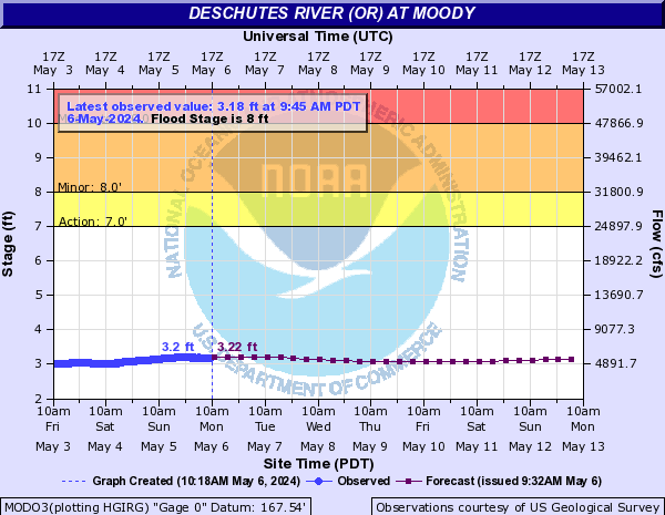
View River Forecast |
| Recommended Flow |
Minimum: 2500.0 Average: 4000.0 Maximum: 9000.0 |
| Typical Season |
Begins: January Ends: December |
| Recommended Use |
Kayaking: Yes Rafting: Yes Canoeing: Yes SUP: Yes Packrafting: No Fishing: Yes |
| Primary Gauge | DESCHUTES RIVER AT MOODY, NEAR BIGGS, OR |
| Length | 63.0 Mile(s) |
| Gradient | 13.0 FPM |
| Type | Name | Description | Camping? | Water? | Boat Ramp? | Vehicle Access |
|---|---|---|---|---|---|---|
| Put-In | Warm Spring State Park Access |
A large, nice boat ramp, parking and facilities are here. Day use only here. No camping. This is just off Highway 26 above the bridge where it crosses the Deschutes. Not far below the dam. |
No | Yes | Yes | All Vehicles |
| Put-In | Trout Creek Access |
This is a good take out option for anglers fishing from warm springs. You can also put in here to cut out some flatwater and class II water and get started with more rapids just downstream. |
Yes | Yes | Yes | All Vehicles |
| Put-In | Nena Access |
A dirt ramp and small day area parking lot on river right. Many anglers that user rafts or floatboats put in or take out here. |
No | No | Yes | All Vehicles |
| Put-In | Long Bend Access |
Ramp on river right. Also some fee camping here. |
Yes | No | Yes | All Vehicles |
| Put-In | Harpham Flat Access |
Fee campground, vehicle access, toilets, tables, garbage service / recycling, trailer parking, and boat ramp. Boater check-in station and visitor information center staffed during summer months. |
Yes | No | Yes | All Vehicles |
| Put-In | Wapinitia Access |
This is a good access to put in on if you just want to run the rapids. This is also a good take out for fishermen floaters. Fee campground, floatboat fishing take out, vehicle access, toilet, tables, garbage service. |
Yes | No | Yes | All Vehicles |
| Put-In | Maupin City Park Access |
This is a full service access point. Probably one of the best you've seen anywhere on any river. You name it and this park has a service for it. Only downfall is it's fee area. |
Yes | Yes | Yes | All Vehicles |
| Take-Out | Sandy Beach Take Out |
This is a mandatory take out on river right. If you float below here you will end up running the class VI Sherars Falls. You don't want to do that. This is an easy ramp to make so pay attention here and take out. |
No | No | Yes | All Vehicles |
| Rapid Name | Description | Scout | Class | Recommended Flow |
|---|---|---|---|---|
| Upper Trout Creek Rapids |
Follow the main tongue just right of center for the deepest channel. Rocky at lower flows |
Read and run |
II to II+ |
Minimum: 2500.0 Maximum: 9000.0 |
| Lower Trout Creek Rapid |
Just below the upper rapid the river makes a right hand bend with a small island towards the left side of the river. Most of the flow follows the right channel. Here there are mainly waves and some sleeper rocks you should be heads up for. The left hand channel can be doable by smaller craft wanting to explore. |
Read and run |
II to II+ |
Minimum: 2500.0 Maximum: 9000.0 |
| Upper Whitehorse Rapid |
A small wave/drop rapid signals it's time to get out on river right to scout white horse rapids just below. |
Read and run |
II to II+ |
Minimum: 2500.0 Maximum: 9000.0 |
| Whitehorse Rapid |
This is longer rapid that requires manuevering throughout. Enter the rapid just right of center. Scouting is recommended since a swim here could result in some bangs. |
Scout river right, well above the entrance to the rapid. Stay clear of the railroad tracks as trains run here often. |
III+ to IV- |
Minimum: 2500.0 Maximum: 9000.0 |
| Buckskin Mary Rapid |
A fun wave train at most levels. Follow the main tongue. Kayakers may find some surf play and eddy access here at the right levels. |
Read and run |
III to III+ |
Minimum: 2500.0 Maximum: 9000.0 |
| Four-chutes Rapid |
Some easy class II water |
read and run |
II to II+ |
Minimum: 2500.0 Maximum: 9000.0 |
| Lower Four-chutes Rapid |
Stick towards river right and follow the bulk of the water flow. |
Read and run |
II to II+ |
Minimum: 2500.0 Maximum: 9000.0 |
| Wapinitia Rapid |
Large rock in the center of the river with possible routes on each side. Most straight forward side is on river right. River left can be a fun wave and hole punch. |
Read and run |
III to III+ |
Minimum: 2500.0 Maximum: 9000.0 |
| Boxcar Rapid |
Waves and a drop over a diagonal ledge. |
Read and run or scout from the road on river right when setting the shuttle. |
III to III+ |
Minimum: 2500.0 Maximum: 9000.0 |
| Surf City Rapid |
Straight forward run. |
Read and run |
II to II+ |
Minimum: 2500.0 Maximum: 9000.0 |
| Oak Springs Rapid |
This is kind of a strange rapid. There are little islands of lava flows scattered throughout. Lava is typically sharp rock so scout and make a clean run to avoid swimming here. |
Scout from river right on the road. |
IV- to IV |
Minimum: 2500.0 Maximum: 9000.0 |
| White River Rapid |
Read and run |
II to II+ |
Minimum: 2500.0 Maximum: 9000.0 |
|
| Upper Elevator Rapid |
A fun wave train |
Read and run |
II to II+ |
Minimum: 2500.0 Maximum: 9000.0 |
| Lower Elevator Rapid |
More wave trains. This rapid has a few rocks on each side of the rapid |
read and run |
II+ to III- |
Minimum: 2500.0 Maximum: 9000.0 |
| Camp Name | Description | Fee? | Beach? |
|---|---|---|---|
| Mecca Flat Camp |
River right. Vehicle access as well on Mecca Road. This isn't far from the warm springs put in. There is a primitive boat ramp and river access here as well. Not a lot of shade here. |
Yes | No |
| Dry Creek Tribal Camp |
This is on river left just past the dry creek mouth. This is on tribal land and requires a tribal permit as well as a fee. Vehicle access to this camp as well. |
Yes | No |
| Luelling Camp |
Small camp on river right |
No | No |
| Grassy Camp |
Several campsites on river right with some shade. |
No | No |
| Stangland Camp |
Several camps with good shade on river right. |
No | No |
| Camp |
A small camp on river right. |
No | No |
| Camp |
A couple of campsites on river right. |
No | No |
| Frog Springs Camp |
A couple of camps on river right. |
No | No |
| Basalt Camp |
A couple of camps on river right. This camp has better shade options than the previouse few. |
No | No |
| Trout Creek Camp |
A large vehicle loop camp. |
Yes | No |
| Redside Camp |
River right |
No | No |
| Lower Redside Camp |
Larger camp with some shade on river right. |
No | No |
| South Junction Camp |
This is car accessible only. River uses would have a very long carry to get to this camp. This camp could make a decent base camp for day trips and fishing on the deschutes though. |
Yes | No |
| Wingdam Camp |
3 campsites on river right. |
No | No |
| Whiskey Dick Camp |
Several large campsites on river right. Some shade and some sandy beaches. |
No | Yes |
| Upper Whitehorse Camp |
2 or 3 medium camps on river right |
No | No |
| Middle Whitehorse Camp |
4 camps on river right. |
No | No |
| Lower Whitehorse Camp |
Several large camps on river right. Some shade and a toilet here. |
No | No |
| Davidson Flat Camp |
Large camp with decent shade and a pit outhouse. |
No | No |
| North Junction Camp |
Another large site on river right with good shade and a toilet. A semi sanding beach at medium to lower flows too. |
No | Yes |
| Dixon Camp |
River left. You are now past tribal land on river left. 3 small sites here. |
No | No |
| Rainbow Bend Camp |
River right. 2 or 3 camps for medium sized groups. Outhouse and some shade. |
No | No |
| Lower Rainbow Bend Camp |
Smaller camp on river right. |
No | No |
| Camp |
2 small secluded camps (other than the railroad noise) on river left. |
No | No |
| Hole in the Wall Camp |
Another 2 smaller camps on river right. Toilet is a short walk down the BLM access road. |
No | No |
| Windy Flat Camp |
3 or 4 large camps on river right. Access to a pit toilet. |
No | No |
| Upper Dant Camp |
A single large group camp on a peninsula on river left. Toilet. |
No | No |
| Buckskin Mary Camp |
several camps on river right. Just below the buckskin mary rapid. |
No | No |
| Four-chutes Camp |
River right. Many camps located on river right from Buckskin Mary rapid down to here. |
No | No |
| Johnson Flat Camps |
This camp and another one just a little downstream are on river left. Toilet access. |
No | No |
| Devils Canyon Campground |
This is a vehicle and river accessible fee camp by the BLM. River right. |
No | No |
| Oasis Campground |
A BLM fee site on river right with river and vehicle access. |
Yes | No |
| Blue Hole Camp |
River right. Fee campground with toilets. Also a fishing platform here which is also wheelchair accessible. |
Yes | No |
| Oak Springs Camp |
River right. Fee campground, vehicle access, toilet, tables, garbage service. |
Yes | No |
| White River Camp |
A nice camp on river right. BLM fee area with some facilities. |
Yes | No |
The following fish species are often found on this run. If you don't see a fish that you know lives on this river, please login and associate that fish species.
No Fish have been associated with this river yet...
| Name | Type |
|---|---|
| Dant Ferry | Historical Place |
| Lady Frances Mine | Historical Place |
| Deschutes Club Gatekeepers House | Historical Place |
No external links or resources added yet...
No community notes added yet...
No Accidents reported for this run...
No River Shuttle Companies added yet...
No River Outfitters, Guides or Commercial Companies added yet...
No Camping or Lodging locations added yet...
